


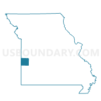
Walker Community Building Voting District, Vernon County, Missouri
About
Outline

Summary
| Unique Area Identifier | 611500 |
| Name | Walker Community Building Voting District |
| County | Vernon County |
| State | Missouri |
| Area (square miles) | 36.34 |
| Land Area (square miles) | 35.95 |
| Water Area (square miles) | 0.39 |
| % of Land Area | 98.94 |
| % of Water Area | 1.06 |
| Latitude of the Internal Point | 37.88396380 |
| Longtitude of the Internal Point | -94.23750720 |
Maps


Graphs
Select a template below for downloading or customizing gragh for Walker Community Building Voting District, Vernon County, Missouri


Neighbors
Neighoring Voting District (by Name) Neighboring Voting District on the Map
- Courthouse Voting District, Vernon County, MO
- Harwood Town Hall Voting District, Vernon County, MO
- Milo Fire Barn Voting District, Vernon County, MO
- Rinehart Christian Church Voting District, Vernon County, MO
- Schell City City Hall Voting District, Vernon County, MO
- Virgil Voting District, Vernon County, MO
- YMCA Voting District, Vernon County, MO
Top 10 Neighboring County Subdivision (by Population) Neighboring County Subdivision on the Map
- Center township, Vernon County, MO (9,664)
- Washington township, Vernon County, MO (2,473)
- Bacon township, Vernon County, MO (669)
- Clear Creek township, Vernon County, MO (645)
- Walker township, Vernon County, MO (536)
- Badger township, Vernon County, MO (476)
- Virgil township, Vernon County, MO (443)
- Blue Mound township, Vernon County, MO (400)
- Osage township, Vernon County, MO (295)
Top 10 Neighboring Place (by Population) Neighboring Place on the Map
Top 10 Neighboring Unified School District (by Population) Neighboring Unified School District on the Map
- Nevada R-V School District, MO (15,264)
- El Dorado Springs R-II School District, MO (8,193)
- Northeast Vernon County R-I School District, MO (2,004)